Our walks in winter
Wengen offers plenty of opportunities for winter walks. Please note that, depending on the weather conditions, you can expect snow or ice. Good hiking equipment is therefore essential.
Walking time to Staubbachbänkli: about 25 minutes and 2.0km
Altitude: 1'268m
Level: easy
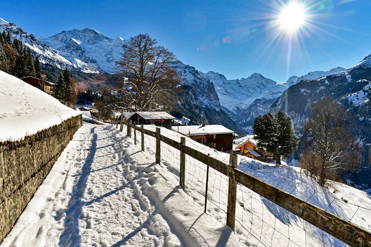
The starting point is Wengen station. From here, head downhill towards the Hotel Bären, where the path forks left towards Innerwengen. The path runs alongside a tarmac road. The path passes the finishing arena for the Lauberhorn international ski races. Just next door are the Café Mary and the Innerwengen snack bar. Five minutes' walk further on is the finish area with its many benches. From here, you have a perfect view of the Staubbacht waterfall. At 297 metres, it is the highest free-falling waterfall in Switzerland.
From late February to around May, if you're lucky, you may spot ibex.
This trail is also perfectly suited to families with pushchairs.
Walking time to Mönchblick: about 30 minutes and 1.8km
Altitude: 1'186m
Level: easy/medium
The starting point is Wengen railway station. From here, you walk along the village street, past the Reformed church and the Hotel Bellevue. The path is asphalted and wide as far as the "Am Sattel" suite. From here, it's another 150 metres to the right along a narrow path until you reach the Mönchblick benches. There is also a bench a few metres further up. Mount Mönch is not normally visible from Wengen. As the name suggests, the summit of the Mönch can be seen from this vantage point.
The route is suitable for families. For the last 150 metres, you may need to leave your pushchair behind.
Walking time to Hunneflue: Approximately 35 minutes and 1.9km
Altitude: 1'363m
Level: Easy
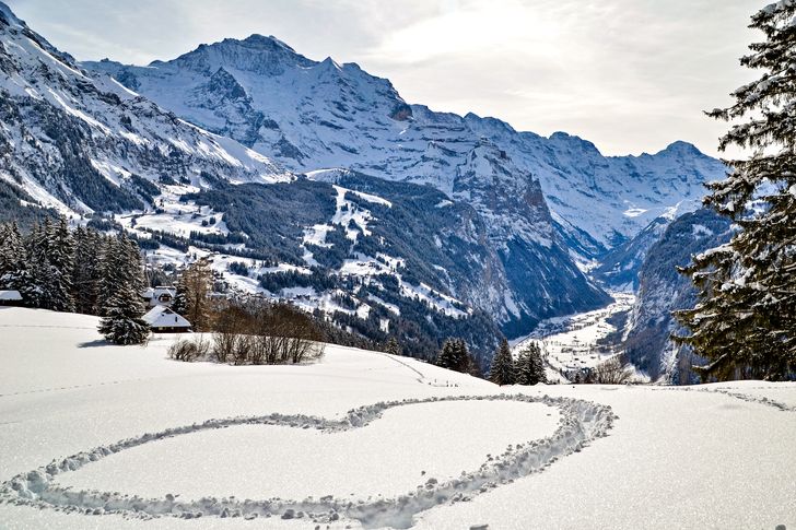
The starting point is Wengen station. From there, follow Dorfstrasse. At the Hotel Palace, turn right, then left again. At the hamlet of "Ledi", you already have a magnificent view of the Lauterbrunnen valley. Continue along the wide path to "am Hubel". After about 50 metres, the final stretch takes you to the Hunneflue viewpoint. You should not venture too close to the balustrade, as the view descends 600 metres vertically into the void. The view extends as far as Interlaken and the Niederhorn, and across the valley to the village of Isenfluh.
This trail is suitable for families and a pushchair can be brought along. Depending on the snow conditions, the last few metres may be difficult to walk.
Tip: At Hunneflue, a path turns right and climbs towards the Leiterhorn. If you have snowshoes or if the path has little or no snow, you can walk up to the Leiterhorn. Return to Wengen via Flüelenboden.
Walking time for the circuit: about 35 minutes and 2.0km
Level: easy
This route takes you through the village and offers you the best views of the mountain world and the Lauterbrunnen valley. The starting point is Wengen railway station. From there, follow the village street to the Reformed church. It's well worth stopping at the Reformed Church to admire the panorama. The path then continues as far as the Hotel Bellevue, where it turns right and heads back towards the mountains. The route continues on the tracks of the Wengernalpbahn. Here, it's worth taking a photo of the train with the Jungfrau and the Lauterbrunnen valley. The path continues straight on until you reach the Hotel Bären, where it turns left and takes you back to the station.
This route is perfect for walkers who want to stay in the village while enjoying the panoramic views.
Walking time to the Leiterhorn: about 60 minutes and 2.4km
Level: medium
Altitude: 1'526m
The Leiterhorn Trail is primarily a snowshoe trail. Weather permitting, the trail can also be walked in winter boots.
Direct route: from the village of Wengen to Flüelenboden. From there, continue towards the Leiterhorn.
Route : From the village of Wengen towards Hunneflue. From Hunneflue, the path climbs to the right as far as the Leiterhorn. On the way back, you can take the forest path towards Flüelenboden and continue towards the village of Wengen.
The Leiterhorn offers sensational views of the Lauterbrunnen valley and the Eiger, Mönch and Jungfrau peaks. At the end of the path, you can see the other side of the valley as far as Interlaken.
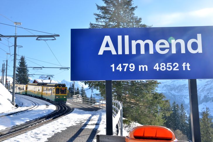
Walking time to Allmend: about 45 minutes and 2.2km
Altitude: 1'479m
Level: easy
From the village of Wengen, walk up the Stutz past the Hotel Regina and Falken. At the junction, take the road on the right (not the ski slope) towards the Allmend. Halfway along, hikers and tobogganers will share the path. From the Allmend, you have the best view of the whole of Wengen. The Allmend also has a mountain restaurant and a stop on the Wengernalpbahn.